The  ougainville Copper Project
Maps Page 1
You are at Page 2 Page 3
Page 4 Page 5
Page 6 Page 7
Page 8 Page 9
Page 10 Page 11
Page 12 Page 12a
Blog
Arovo Island
Links Comments
"Honour Roll"
Location List
The Aftermath Guestbook Like a copy? Today's Graffiti South Coast Property for sale

| |
 Tonight's Movie at Arawa:
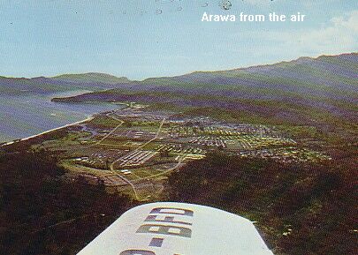 | As the Mine neared completion, so did Arawa, the "dormitory town" for most of the mine workers. What had been a beautiful copra plantation on the long sweep of a black-beach bay, became a bustling town with supermarket, tavern, post office, and a general hospital which was the best in the Territory. A total of 446 residences were completed in 20 months employing a labour force of some 600. Seven different houses were built ranging from 3 to 4 bedroom residences, some fully air conditioned. |
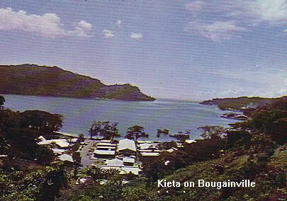 | But there was always Kieta with its hotel, the Kieta Club, the sailing club, a branch of Breckwoldts, several Chinese shops, and Green & Co on the waterfront. This shop as no other catered to the "touristy" needs of the mine population with postcards of 'maris' suckling pigs, carvings, grass skirts, and tee shirts. And beyond it, Aropa Airstrip, the 'Gateway to Freedom' after the daily 10-hour grind of the construction work. |
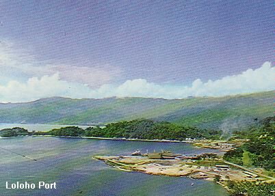 | The Loloho Powerhouse had already been built to supply power to the copper concentrator, mine, portsite facilities and townships of Arawa and Panguna via a 132 KV transmission system. Loloho Port was also nearing completion. What a moment when the first Japanese ore carrier tied up alongside it! The beach at Camp 6 was always an attraction for those of us who lived at the Minesite and had to endure daily downpours and mud and slush. |
 | The construction of the new 16-mile 24 ft wide Mine Access Road through the Crown Prince Range posed many problems and was the most spectacular of all the work undertaken. It became trafficable in October 1970 and, except for a few major deviations, followed the route of the first access road built by C.R.A. Building it involved a mammoth earth moving operation: ridge tops were cut off and sometimes used to fill ravines to provide a gradually ascending route. A complicated bench system often rising 200 ft. above the road was necessary in some sections to protect it against landslides and also to allow for the effect of earth tremors in the area. |
| Share your memories of Bougainville with the rest of us. |
Email us at riverbend@batemansbay.com
Maps To Page 1 You are at Page 2 Page 3 Page 4 Page 5 Page 6 Page 7 Page 8 Page 9 Page 10 Page 11 Page 12 Page 12a
Arovo Island Links Comments "Honour Roll" The Aftermath Guestbook
My trip to Samoa An Island to Oneself Pigeon Island Your holiday destination in Australia
Copyright © 2003 Peter Goerman